Bass River State Forest Map
Created By: Boyd
Last Updated: December 2nd, 2009 5:12pm
Map Coverage:
North: 39.7146°
West: 74.5316°
East: 74.318°
South: 39.5665°
Country: United States
State: New Jersey
Price: Free
![]()
![]()
![]()
![]()
![]()
![]()
![]()
![]()
Most Popular Maps
- My Trails-High Quality Trail and POI Maps
- Arizona Topo
- World Topo - Eastern
- Florida Topo
- World shaded relief kmz
Other Maps By Boyd (See All)

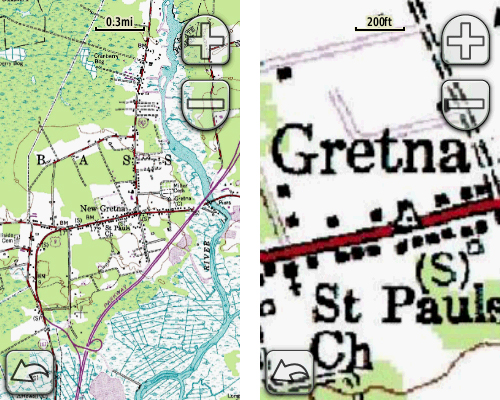
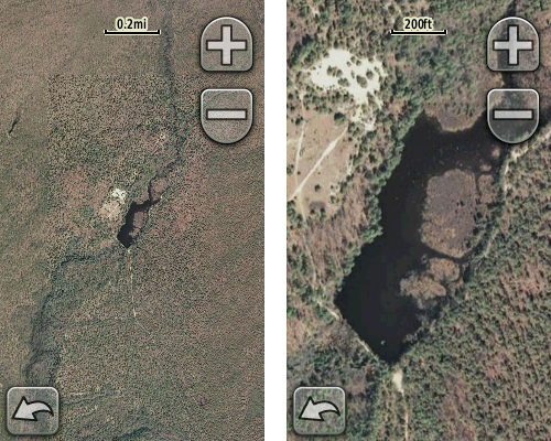
This zip archive contains both a USGS 1:24000 topo map and NJ 2007 digital orthophotography of Bass River State Forest in the New Jersey Pine Barrens. The USGS topo covers an area approximately 11.4 miles x 10 miles at a resolution of ~8 feet per pixel. The NJ 2007 aerial imagery covers an area about 6.9 miles x 4.7 miles at a resolution of ~4 feet per pixel.
These maps are only compatible with the Garmin Oregon, Dakota and Colorado series using the current firmware. If your unit does not recognize this map, connect it to your computer and run Garmin WebUpdater to install the newest firmware.
This file is compatible with both Macs and Windows machines. Unzip, choose the map you want and drop it into your CustomMaps folder on the GPS. The CustomMaps folder must be inside the Garmin folder and may be located either in internal memory or on a storage card.
As of this writing, Garmin does not support more than one custom mapset at a time. Choose only ONE of the two files in the zip archive. These files can also be viewed with Google Earth, or any other software which supports .kmz files. Not compatible with Mapsource.
Screenshots below are from an Oregon 400


 Download Garmin Custom Map [36MB] (1922 Downloads)