deprecated Map
Created By: yogazoo
Last Updated: May 3rd, 2014 2:05pm
Map Coverage:
North: 49.0004°
West: -116.051°
East: -104.039°
South: 44.3573°
Country: United States
State: Montana
Price: FREE
![]()
![]()
![]()
Most Popular Maps
- My Trails-High Quality Trail and POI Maps
- Arizona Topo
- World Topo - Eastern
- Florida Topo
- World shaded relief kmz
Other Maps By yogazoo (See All)
I've always been proud to live in a state where GIS data is so plentiful, detailed, and important. From our Cadastral mapping (mapping of each and every land parcel in the entire state) to our aerial photography (2009 infrared/NAIP) Montana is hard to beat when it comes to freely available geospatial data.
I digress. This .gpi file was created by Garmin's POI loader. You can place this file directly into the "POI" folder on your unit or create a folder named "POI" if you don't already have one. For those of you who would like to use POI loader to load these databases onto an older unit, I have included the CSV files with the custom symbols.
What does it do? This POI file contains two seperate databases 1) "Structure-Name" and 2) "Structure-Address". You can select which one to query based on what information you have to locate a particular house. If you have the address and you don't have City Navigator you can use the Structure-Address database. If you know the persons name but have no idea where they might live you can search the database by name. That's right, just enter a name to query and the databse will produce hits based on your location.
Online Direct Download link: STRUCTURES POI.gpi
The MAC version isn't updated since I can't upload a .zip file into the mac download button (even though ever since the previous millenia people with MAC's could unzip .zip files)
 Download Windows Version [28MB] (1672 Downloads)
All you have to do to get these POI's to show up on your Garmin GPS is:
1) Create a folder named "POI" in your "Garmin" folder on either your SD card or internal memory.
2) Unzip the download and place the "STRUCTURES POI.gpi" file inside that "POI" folder.
3) You can search each database by going to "Where To?" and then "Extras".
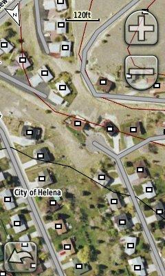
The image below is an example of how this custom POI database might look on your GPS screen (this example overlays Birdseye Imagery from Garmin). The white squares with black outline are symbols I used (now small red crosses).