Connecticut: East Lyme: Rocky Neck State Park Map
Created By: dbperry
Last Updated: December 21st, 2012 8:12pm
Map Coverage:
North: 41.3181°
West: -72.2556°
East: -72.2338°
South: 41.2932°
Country: United States
State: Connecticut
Price: Free
![]()
![]()
![]()
![]()
![]()
![]()
Most Popular Maps
- My Trails-High Quality Trail and POI Maps
- Arizona Topo
- World Topo - Eastern
- Florida Topo
- World shaded relief kmz
Other Maps By dbperry (See All)
Rocky Neck State Park, East Lyme, CT 06357
CLICK HERE to preview the KMZ map in Google Maps
One of the most popular beaches in Connecticut, Rocky Neck also offers hiking trails and a campground. Well known by all of us Amtrak NE Corridor commuters who pass through the park and wave to the beach goers while passing by on the Acela.
More information about this property at:
http://www.ct.gov/dep/rockyneck
and
http://en.wikipedia.org/wiki/Rocky_Neck_State_Park
Source Data
My KMZ map is from the CT DEP map at:
http://www.ct.gov/dep/lib/dep/stateparks/maps/rockyneck.pdf
(See Version History below for more information)
Screenshots
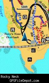
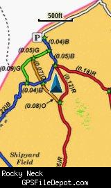
This KMZ map is set to Draw Order 32 so it will show 'beneath' your primary map on your Garmin KMZ-compatible GPS.
Both images are from a Garmin GPSMAP 78sc with no other maps displayed.
Download
I have posted this KMZ as freeware, so instead of paying me for it, send me a note if you found this file helpful!
[email protected]
 Download Garmin Custom Map [314kB] (1105 Downloads)
Once you have downloaded and unzipped the KMZ file, you can:
1) Display it on your Garmin GPS receiver by placing the file in the \Garmin\CustomMaps folder on your supported Garmin GPS receiver. For a list of supported devices, click here.
2) Display it in Google Earth by opening the file (FILE, OPEN).
Notification of Updates
If you would like to be notified when I update this or any of my KMZ maps, subscribe to my notification e-mail service by sending an e-mail to [email protected] with the subject line "subscribe gps_maps"
This is a notification list only, and the only posts you will receive are when my KMZ maps are updated. Your e-mail address will not be used for any other purpose (or provided to anyone else except me).
Support The Effort
If you find the map and this website useful please consider making a donation to offset hosting costs.
* You don't need paypal to donate but that is who will process the donation.
Version History
Note: file re-uploaded on 12/21/12, but nothing changed except the file name.
Version 1.00 (2012 August 27)
Initial release using CT DEP map dated January 30, 2009.
Map Summary
Site details:
Name: Rocky Neck State Park
Owner / Steward: CT DEEP
State: Connecticut
County: New London
Primary city / town: East Lyme
Primary city / town zip code: 06357
Other cities / towns in map area: <none>
Area of conservation / recreation land: 584 acres or 0.91 square miles
NOTE: This is my calculation of the extents of the area(s) with publicly accessible trails on the KMZ map. This should be the area available for hiking or other recreation, but it will also include any portion of water bodies, marshes, swamps, etc. within the boundaries of the properties on the KMZ. It would also include inaccessible conservation land within the boundaries, such as a buffer zone of "Do not enter" land around a reservoir.
KMZ details:
File name: Rocky_Neck_ver_1.00.kmz
Current version: 1.00
Date published: 8/27/2012
Number of tiles: 1
KMZ file size: 319 KB
Draw order: 32
Does this KMZ overlap with any others? No
If so, which ones? <N-A>
Coverage of KMZ: 1,229 acres or 1.92 square miles
NOTE: this area includes the ENTIRE KMZ including white space / margins / legend, etc.
Lat / Long of center of KMZ polygon (not necessarily the center of the map):
N 41° 18.335'
W 72° 14.678'