Massachusetts: Fall River: SE Mass Bioreserve Map
Created By: dbperry
Last Updated: September 8th, 2013 10:09pm
Map Coverage:
North: 41.7553°
West: -71.1011°
East: -71.0381°
South: 41.6947°
Country: United States
State: Massachusetts
Price: Free
![]()
![]()
![]()
![]()
![]()
![]()
![]()
Most Popular Maps
- My Trails-High Quality Trail and POI Maps
- Arizona Topo
- World Topo - Eastern
- Florida Topo
- World shaded relief kmz
Other Maps By dbperry (See All)
Southeastern Massachusetts Bioreserve, Fall River MA 02790
Location Information
Nestled between Watuppa Pond and the Copicut Reservoir, the Southeastern Massachusetts Bioreserve is a unique conglomeration of preserved and conserved land stewarded by multiple public and private agencies. Started in 2002, it now includes over 14,000 acres of conservation land.
More information at:
http://www.greenfutures.org/projects/green/biofacts.html
and
http://www.tauntongazette.com/newsnow/x1942597468/OUR-VIEW-Southeastern-Mass-Bioreserve-should-not-be-a-secret
Source Data
Oddly enough, the PDF map of area is not officially posted (at least as best as I can tell as of today). My KMZ map is from a scan of the map I found on this forum:
http://forums.mtbr.com/massachusetts/se-mass-bioreserve-freetown-sf-828991-2.html
See version history below for more information.
iPhone / Android / Google Map Links
The links below will allow you to view an interactive version of the KMZ trail map on your computer or on your mobile device (iPhone / iPad / Android). By allowing the Google Maps website to 'use your location' on your device, you will be able to see your position displayed on the Google Map.
When opening the links on your iPhone, don't use the Google Maps app - allow the browser to open the link on the Google Maps website.
CLICK HERE to view the SE Mass Bioreserve KMZ map in Gmap4 (terrain shaded map)
CLICK HERE to view the SE Mass Bioreserve KMZ map in Google Maps
Screenshots
This KMZ map is set to Draw Order 32 so it will show 'beneath' your primary map on your Garmin KMZ-compatible GPS.
Note that due to the wide coverage area of this map, it is actually 4 tiles. Keep that in mind when placing this on your Garmin GPSr - even though this is one KMZ, the number of tiles is limited to 100 across all the KMZ files loaded on most Garmin GPSr models (500 tiles if you have a Garmin Montana or Oregon 600 series).
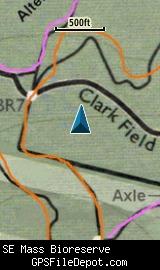
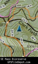
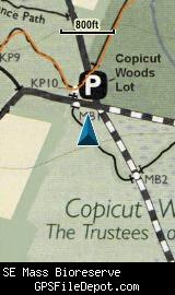
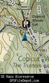
The images below are all from a Garmin GPSMAP 78sc. The image on the left is with no other maps displayed. The image on the right has the Garmin 24K NE series TOPO maps displayed.
Download
This KMZ is posted as freeware, so instead of paying for it, send me a note if you found this file helpful!
[email protected]
 Download Garmin Custom Map [3MB] (1477 Downloads)
Once you have downloaded and unzipped the KMZ file, you can:
1) Display it on your Garmin GPS receiver by placing the file in the \Garmin\CustomMaps folder on your supported Garmin GPS receiver. For a list of supported devices, click here.
2) Display it in Google Earth by opening the file (FILE, OPEN).
Notification of Updates
If you would like to be notified when I update this or any of my KMZ maps, subscribe to my notification e-mail service by sending an e-mail to [email protected] with the subject line "subscribe gps_maps"
This is a notification list only, and the only posts you will receive are when my KMZ maps are updated. Your e-mail address will not be used for any other purpose (or provided to anyone else except me).
Support The Effort
If you find the map and this website useful please consider making a donation to offset hosting costs.
* You don't need paypal to donate but that is who will process the donation.
Version History
Version 1.00 (9/9/2013)
Initial release using undated map downloaded on 9/8/2013.
Map Summary
Site details:
Name: Southeastern Massachusetts Bioreserve
Owner / Steward: various / multiple
State: Massachusetts
County: Bristol
Primary city / town: Fall River
Primary city / town zip code: 02790
Other cities / towns in map area: Dartmouth, Freetown
Area of conservation / recreation land: 7,127 acres or 11.14 square miles
NOTE: This is my calculation of the extents of the area(s) with publicly accessible trails on the KMZ map. This should be the area available for hiking or other recreation, but it will also include any portion of water bodies, marshes, swamps, etc. within the boundaries of the properties on the KMZ. It would also include inaccessible conservation land within the boundaries, such as a buffer zone of "Do not enter" land around a reservoir.
KMZ details:
File name: SE_MA_Bioreserve_ver_1.00.kmz
Current version: 1.00
Date published: 9/9/2013
Number of tiles: 4
KMZ file size: 2,777 KB
Draw order: 32
Does this KMZ overlap with any others? No
If so, which ones? N-A
Coverage of KMZ: 8,309 acres or 12.98 square miles
NOTE: this area includes the ENTIRE KMZ including white space / margins / legend, etc.
GPS coordinates of center of KMZ polygon (not necessarily the center of the map):
N 42° 43.501'
W 71° 04.172'