North Cumberland OHV / ATV Trails v2.3, TN Map
Created By: eaparks
Last Updated: February 25th, 2014 4:02pm
Map Coverage:
North: 36.5949°
West: 84.5785°
East: 84.0511°
South: 35.9439°
Country: United States
State: Tennessee
Price: Free
![]()
![]()
![]()
![]()
![]()
![]()
![]()
Most Popular Maps
- My Trails-High Quality Trail and POI Maps
- Arizona Topo
- World Topo - Eastern
- Florida Topo
- World shaded relief kmz
Other Maps By eaparks (See All)
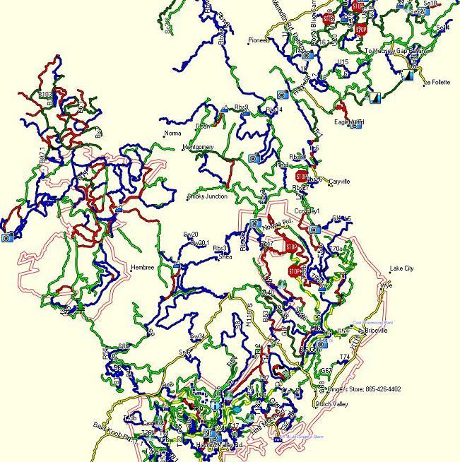
North Cumberland Trails, TN. GPS map for Garmin GPSes covering OHV / ATV trails for the North Cumberland Plateau area North and West of Knoxville, TN.
Trail areas included are: Royal Blue WMA, Sundquist WMA, New River WMA, Brimstone, and Windrock / Coal Creek. More than 1,000 miles of OHV trails and roads. All trails are color coded by trail difficulty (Can also be seen in the Readme.txt file after downloading).
1-23-11 - original map: combined older Windrock / Coal Creek map into North Cumberland Trails.
8-21-13 - Added Map image. Added a few trails & POIs, improved accuracy of several trails, changed trail color of some major gravel roads to Yellow/Green dashed line.
2-25-14 - Updated trail T54, thanks to CAThomas for the updated tracks.
Trail Color Designations are as follows:
- White line with red border = Property Boundaries; i.e... WMA areas, Private Property, etc
- Yellow line = Paved Roads
- Yellow and Green Dashed line = Main Gravel Roads
- Green line = Easiest Trails (includes gravel roads)
- Blue line = Intermediate Trails
- Red line = Difficult Trails
- Red and Black Dashed line = Extremely Difficult Trails
- Blue Dashed line = Single Track Mtn. Bike Trails
There are lots of POIs included for such things of interest as: Trail Heads / Vehicle Parking, Trail Name / Number, Campgrounds, Scenic Overlooks, Waterfalls, Windmills, and a restaurant you can ride to for lunch.
Before installing North Cumberland Trails v2.3, manually uninstall my previous version of North Cumberland Trails if you had downloaded and installed it from GPSFileDepot.com.
 Download Windows Version [710kB] (31642 Downloads)