Massachusetts: Ashland Town Forest Map
Created By: dbperry
Last Updated: May 11th, 2012 5:05pm
Map Coverage:
North: 42.2868°
West: -71.4967°
East: -71.4598°
South: 42.2633°
Country: United States
State: Massachusetts
Price: Free
![]()
![]()
![]()
![]()
![]()
![]()
![]()
Most Popular Maps
- My Trails-High Quality Trail and POI Maps
- Arizona Topo
- World Topo - Eastern
- WV-VA-KY Dec-29 2025 Public Map
- Florida Topo
Other Maps By dbperry (See All)
Ashland Town Forest, Ashland, MA 01721
Also known as the Cowassock Woods, this area includes property owned by the town of Ashland and the Sudbury Valley Trustees. The Bay Circuit Trail runs through the heart of the Ashland Town Forest.
More information about this property at:
http://www.sudburyvalleytrustees.org/maps?q=node/155
and
http://www.ashlandtownforest.org/
If you enjoy this property, consider joining the Sudbury Valley Trustees as a member:
http://www.sudburyvalleytrustees.org/join
Source Data
My KMZ map is created from the Sudbury Valley Trustees map (with permission):
http://www.sudburyvalleytrustees.org/sites/default/files/Cowassock.pdf
See version history below for more info.
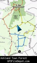
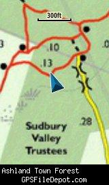
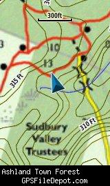
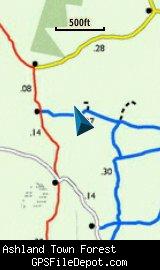
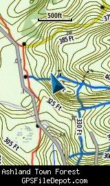
Screenshots
This KMZ map is set to Draw Order 32 so it will show 'beneath' your primary map on your Garmin KMZ-compatible GPS.
The images below are all from a Garmin GPSMAP 78sc. The first image is with no other maps displayed. The next two rows have an image on the left with no other map displayed while the image on the right has the Garmin 24K NE series TOPO maps displayed.
Download
I have posted this KMZ as freeware, so instead of paying me for it, send me a note if you found this file helpful!
[email protected]
 Download Garmin Custom Map [212kB] (1333 Downloads)
Once you have downloaded and unzipped the KMZ file, you can:
1) Display it on your Garmin GPS receiver by placing the file in the \Garmin\CustomMaps folder on your supported Garmin GPS receiver. For a list of supported devices, click here.
2) Display it in Google Earth by opening the file (FILE, OPEN).
Notification of Updates
If you would like to be notified when I update this or any of my KMZ maps, subscribe to my notification e-mail service by sending an e-mail to [email protected] with the subject line "subscribe gps_maps"
This is a notification list only, and the only posts you will receive are when my KMZ maps are updated. Your e-mail address will not be used for any other purpose (or provided to anyone else except me).
Support The Effort
If you find the map and this website useful please consider making a donation to offset hosting costs.
* You don't need paypal to donate but that is who will process the donation.
Version History
Version 1.03 (2012 May 11)
Fixed a zip file error.
Version 1.02 (2012 May 7)
Removed spaces from file names (KMZ and JPG)
Version 1.01 (2012 Jan 21)
Changed draw order to 32.
Version 1.00 (2012 Jan 4)
Initial release using undated map downloaded from Sudbury Valley Trustees website (see above) on Jan 2, 2012.