Massachusetts: Milton: Blue Hills Reservation Map
Created By: dbperry
Last Updated: July 28th, 2015 9:07pm
Map Coverage:
North: 42.2471°
West: -71.1531°
East: -71.0254°
South: 42.1801°
Country: United States
State: Massachusetts
Price: Free
![]()
![]()
![]()
![]()
![]()
![]()
Most Popular Maps
- My Trails-High Quality Trail and POI Maps
- Arizona Topo
- World Topo - Eastern
- Florida Topo
- World shaded relief kmz
Other Maps By dbperry (See All)
Blue Hills Reservation, Milton, MA 02186
Location Information
A massive (at least for suburban Boston) and historic State Reservation, encompassing property in five Eastern Massachusetts towns: Milton, Canton, Randolph, Quincy, and Braintree.
A weather observatory, a ski area, a covered drinking water storage tank (reservoir) for Boston, a former granite quarry, a trailside ecology museum, a pond with a beach for swimming, and miles of trails are all within the extents of this map.
More information at:
http://www.mass.gov/eea/agencies/dcr/massparks/region-south/blue-hills-reservation.html
and
http://www.friendsofthebluehills.org/
and
http://en.wikipedia.org/wiki/Blue_Hills_Reservation
and
http://ski-bluehills.com/
Source Data
My KMZ map is from the DCR map:
http://www.mass.gov/eea/docs/dcr/parks/trails/blue-2015.pdf
See version history below for more info.
iPhone / iPad / Android / internet browser map
The link below will allow you to view an interactive version of the KMZ trail map on your computer or on your mobile device (iPhone / iPad / Android). Once you have the map loaded up in your broswer, click on the MENU option in the lower right corner and turn "My Location" to "ON" and you will be able to see your position displayed on the map (assuming your phone can calculate your position).
CLICK HERE to view the Blue Hills KMZ map in Gmap4 (terrain shaded map)
NOTE: This browser based rendering of the map does not support rotation. The actual KMZ file is rotated slightly to align properly to the world. The KMZ map displayed at the link above is therefore not perfect since the browser based map is ignoring the rotation. The result is that the tiles appear 'jagged' and misaligned in the browser based version at the link above. If you download the KMZ file (from the download link below) and open the KMZ in Google EARTH (or on a Garmin GPSr), the KMZ will appear accurate and not jagged or misaligned. It also appears transparent in Google Earth, which is another feature that the browser based version does not support. The error introduced by the lack of rotation should not be enough to matter in terms of using the map to navigate. As with all maps on this site, no warranty of performance is provided and this map should not be relied on as a sole method of navigation.
Screenshots
This KMZ map is set to Draw Order 32 so it will show 'beneath' your primary map on your Garmin KMZ-compatible GPS.
Note that due to the wide coverage area of this map, it is actually 24 tiles. Keep that in mind when placing this on your Garmin GPS - even though this is one KMZ, the number of tiles is limited to 100 across all the KMZ files loaded on your GPS.
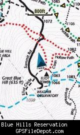
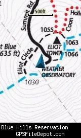
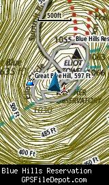
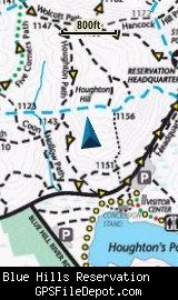
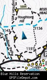
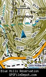
All of the images below are from a Garmin GPSMAP 78sc.
The images below are the top of Great Blue Hill. The images on the left are with no other maps displayed. The image on the right is with the Garmin 24K NE series TOPO maps displayed.
The images below are from the Houghton's Pond area. The images on the left are with no other maps displayed. The image on the right is with the Garmin 24K NE series TOPO maps displayed.
Download
I have posted this KMZ as freeware, so instead of paying me for it, send me a note if you found this file helpful!
[email protected]
 Download Garmin Custom Map [9MB] (2365 Downloads)
Once you have downloaded and unzipped the KMZ file, you can:
1) Display it on your Garmin GPS receiver by placing the file in the \Garmin\CustomMaps folder on your supported Garmin GPS receiver. For a list of supported devices, click here.
2) Display it in Google Earth by opening the file (FILE, OPEN).
Notification of Updates
If you would like to be notified when I update this or any of my KMZ maps, subscribe to my notification e-mail service by sending an e-mail to [email protected] with the subject line "subscribe gps_maps"
This is a notification list only, and the only posts you will receive are when my KMZ maps are updated. Your e-mail address will not be used for any other purpose (or provided to anyone else except me).
Support The Effort
If you find the map and this website useful please consider making a donation to offset hosting costs.
![]()
* You don't need paypal to donate but that is who will process the donation.
Version History
Version 3.00 (2015 July 29)
Recreated new KMZ map using DCR map dated June 2015
Version 2.01 (2013 June 1)
Version 7 of Google Earth introduced a new 'feature' - when opening KMZ files, the view automatically 'tilts' to an oblique angle. By specifying the tilt angle (zero) in the KML file, this version of the Blue Hills KMZ map (2.01) prevents Google Earth from tilting the view. There were no other changes to the map - so if you don't mind the tilt view in Google Earth, or if you are not using this KMZ file in Google Earth, there is no reason to download this update.
Version 2.00 (2012 Sept 18)
Recreated new KMZ map using DCR map dated December 2011
Version 1.00 (2012 Jan 29)
Initial release using DCR map dated September 2010
Map Summary
Site details:
Name: Blue Hills
Owner / Steward: DCR
State: Massachusetts
County: Norfolk and Suffolk
Primary city / town: Milton
Primary city / town zip code: 02186
Other cities / towns in map area: Boston, Canton, Quincy, Braintree, Westwood, Dedham, Randolph.
Area of conservation / recreation land: 7,424 acres or 11.60 square miles
NOTE: This is my calculation of the extents of the area(s) with publicly accessible trails on the KMZ map. This should be the area available for hiking or other recreation, but it will also include any portion of water bodies, marshes, swamps, etc. within the boundaries of the properties on the KMZ. It would also include inaccessible conservation land within the boundaries, such as a buffer zone of "Do not enter" land around a reservoir.
KMZ details:
File name: Blue_Hills_ver_3.00.kmz
Current version: 3.00
Date published: 7/29/2015
Number of tiles: 24
KMZ file size: 9,006 KB
Draw order: 32
Does this KMZ overlap with any others? No
If so, which ones? N-A
Coverage of KMZ: 19,261 acres or 30.10 square miles
NOTE: this area includes the ENTIRE KMZ including white space / margins / legend, etc.
GPS coordinates of center of KMZ polygon (not necessarily the center of the map):
N 42° 12.816'
W 71° 05.347'