Massachusetts: Framingham: Hop Brook Natural Area Map
Created By: dbperry
Last Updated: May 24th, 2012 8:05pm
Map Coverage:
North: 42.332°
West: -71.4634°
East: -71.453°
South: 42.3234°
Country: United States
State: Massachusetts
Price: Free
![]()
![]()
![]()
![]()
![]()
![]()
![]()
Most Popular Maps
- My Trails-High Quality Trail and POI Maps
- Arizona Topo
- World Topo - Eastern
- WV-VA-KY Dec-29 2025 Public Map
- Florida Topo
Other Maps By dbperry (See All)
Hop Brook Natural Area, Framingham, MA 01701
Hop Brook starts just to the east of Grove Street in Framingham and flows west and north, passing through the Garden in the Woods and eventually discharging into the Sudbury River in Wayland.
The Sudbury Valley Trustees owns a small parcel of land along Hop Brook, close to its headwaters.
More information at:
http://www.sudburyvalleytrustees.org/maps?q=node/2653
Source Data
My KMZ map is from the Sudbury Valley Trustees map and brochure (with permission):
http://www.sudburyvalleytrustees.org/sites/default/files/HopBrookNA.pdf
(See Version History below for more information)
The trail map / brochure at the link above has interpretive descriptions of the numbered stations on the map. Download the brochure and follow along on your hike!
This KMZ is actually completely within the NW Framingham KMZ, and the NW Framingham KMZ has the Hop Brook trail on it. However, the purpose of having this KMZ as a seperate file is for two reasons:
a) higher resolution on this large scale map; and
b) this KMZ includes the interpretive stations on the Hop Brook trail (the NW Framingham KMZ does not).
If you enjoy this property, consider joining the SVT as a member:
http://www.sudburyvalleytrustees.org/join
Bay Circuit "E to K" KMZ Series
Northwest Framingham and the adjoining parts of Sudbury and Marlborough contain many different publicly accessible conservation parcels, owned by a number of different entities. Unfortunately, that means that there is not a good consolidated detailed trail map for this whole region. However, I have made a series of KMZ maps - my "Bay Circuit 'E to K' KMZ Series" - that work together to provide seamless coverage for this area on your GPSr. Each KMZ file overlaps with at least one other in the series, but by cropping the files and setting a precise draw order for each one, there is no loss of coverage even with all the KMZ files displayed on your GPSr at the same time.
Note that this series of KMZ maps contains more trails than just the Bay Circuit Trail. For example, the entire Callahan State Park is included, even though the majority of the trails are south of the Bay Circuit Trail. I'm calling my series the "Bay Circuit 'E to K' KMZ Series" since there is a nice overview map on the Bay Circuit Trail website and because I can't think of anything else to call it!
The area encompassed by my "Bay Circuit 'E to K' KMZ Series" is from point 'E' in Sudbury to point 'K' in Marlborough on map #8 of the Bay Circuit Trail:
http://www.baycircuit.org/Map8.pdf
A description of this map is available here:
http://www.baycircuit.org/section8.pdf
and the entire Bay Circuit Trail is described here:
http://www.baycircuit.org/
Working from the Northeast to the Southwest, the KMZ files in my "Bay Circuit 'E to K' KMZ Series" are:
Nobscot Reservation
http://www.gpsfiledepot.com/maps/view/574
This 6 tile KMZ is set to draw order 35 so that it appears under your primary IMG file, under Hop Brook, under Northwest Framingham, and over Callahan State Park.
Northwest Framingham
http://www.gpsfiledepot.com/maps/view/607/
This 6 tile KMZ is set to draw order 40 so that it appears under your primary IMG file and under Hop Brook but over Nobscot and Callahan State Park.
Hop Brook Natural Area
http://www.gpsfiledepot.com/maps/view/606/
This 1 tile KMZ is set to draw order 45 so that it appears under your primary IMG file, but over Nobscot, Northwest Framingham and Callahan State Park.
Callahan State Park
http://www.gpsfiledepot.com/maps/view/605/
This 9 tile KMZ is set to draw order 32 so that it appears under your primary IMG file and also under Nobscot, Northwest Framingham and Callahan State Park. Note that another author has posted a Callahan State Park KMZ on gpsfiledepot.com, but the draw order of that KMZ is not conducive to the 'layering' I wanted to achieve. So that is why I made my own.
But it probably isn't worth worrying about all the different draw orders - download all the KMZ in the series and put them all on your GPSr and you should be happy. But the information above is provided for those of you who do need it.
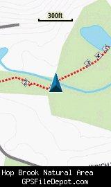
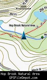
Screenshots
This KMZ map is set to Draw Order 45 (as described above).
The image on the left is from a Garmin GPSMAP 78sc with no other maps displayed. The image on the right is from the same device with the Garmin 24K NE series TOPO maps displayed.
Download
I have posted this KMZ as freeware, so instead of paying me for it, send me a note if you found this file helpful!
[email protected]
 Download Garmin Custom Map [186kB] (1729 Downloads)
Once you have downloaded and unzipped the KMZ file, you can:
1) Display it on your Garmin GPS receiver by placing the file in the \Garmin\CustomMaps folder on your supported Garmin GPS receiver. For a list of supported devices, click here.
2) Display it in Google Earth by opening the file (FILE, OPEN).
Notification of Updates
If you would like to be notified when I update this or any of my KMZ maps, subscribe to my notification e-mail service by sending an e-mail to [email protected] with the subject line "subscribe gps_maps"
This is a notification list only, and the only posts you will receive are when my KMZ maps are updated. Your e-mail address will not be used for any other purpose (or provided to anyone else except me).
Support The Effort
If you find the map and this website useful please consider making a donation to offset hosting costs.
* You don't need paypal to donate but that is who will process the donation.
Version History
Version 1.00 (2012 May 19)
Initial release using undated Sudbury Valley Trustees map downloaded on 3/18/12