Massachusetts: Sherborn: Rocky Narrows Map
Created By: dbperry
Last Updated: May 12th, 2012 3:05pm
Map Coverage:
North: 42.2274°
West: -71.3628°
East: -71.3361°
South: 42.2092°
Country: United States
State: Massachusetts
Price: Free
![]()
![]()
![]()
![]()
![]()
![]()
![]()
Most Popular Maps
- My Trails-High Quality Trail and POI Maps
- Arizona Topo
- World Topo - Eastern
- Florida Topo
- WV-VA-KY Feb 3 2025 Public Map
Other Maps By dbperry (See All)
Rocky Narrows, Sherborn MA 01770
Rocky Narrows is primarily in Sherborn MA, although portions are also in Medfield and Dover. It is made up of properties owned by the Trustees of Reservations and the Sherborn Town Forest.
More information at:
http://www.thetrustees.org/places-to-visit/greater-boston/rocky-narrows.html
and
http://www.sherbornforestandtrail.org/trails/maps/25-rocky-narrows
and
http://www.metrowestdailynews.com/news/x1158233838
Source Data
KMZ map from Trustees of Reservations map (with permission) at:
http://www.thetrustees.org/assets/documents/places-to-visit/trailmaps/Rocky-Narrows-Trail-Map.pdf
See version history below for more information.
If you enjoy using properties owned by the Trustees of Reservations, consider becoming a member:
http://www.thetrustees.org/membership/
iPhone / Android / Google Map Links
The links below will allow you to view an interactive version of the KMZ trail map on your computer or on your mobile device (iPhone / iPad / Android). By allowing the Google Maps website to 'use your location' on your device, you will be able to see your position displayed on the Google Map.
When opening the links on your iPhone, don't use the Google Maps app - allow the browser to open the link on the Google Maps website.
CLICK HERE to view the Rocky Narrows KMZ map in Google Maps
CLICK HERE to view the Rocky Narrows KMZ map in Gmap4 (terrain shaded map)
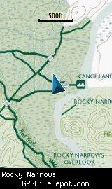
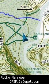
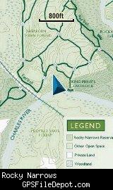
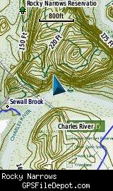
Screenshots
This KMZ map is set to Draw Order 32 so it will show 'beneath' your primary map on your Garmin KMZ-compatible GPS.
The images below are all from a Garmin GPSMAP 78sc. The image on the left in both rows is with no other maps displayed. The image on the right in both rows has the Garmin 24K NE series TOPO maps displayed.
Download
This KMZ is posted as freeware, so instead of paying for it, send me a note if you found this file helpful!
[email protected]
 Download Garmin Custom Map [462kB] (1132 Downloads)
Once you have downloaded and unzipped the KMZ file, you can:
1) Display it on your Garmin GPS receiver by placing the file in the \Garmin\CustomMaps folder on your supported Garmin GPS receiver. For a list of supported devices, click here.
2) Display it in Google Earth by opening the file (FILE, OPEN).
Notification of Updates
If you would like to be notified when I update this or any of my KMZ maps, subscribe to my notification e-mail service by sending an e-mail to [email protected] with the subject line "subscribe gps_maps"
This is a notification list only, and the only posts you will receive are when my KMZ maps are updated. Your e-mail address will not be used for any other purpose (or provided to anyone else except me).
Support The Effort
If you find the map and this website useful please consider making a donation to offset hosting costs.
 Support GPSFileDepot
* You don't need paypal to donate but that is who will process the donation.
Version History
Version 1.01 (2012 May 12)
Removed spaces from file names (KMZ, JPG).
Version 1.00 (2012 Jan 23)
Initial release using Trustees of Reservation map dated August 2010.
Map Summary
Site details:
Name: Rocky Narrows
Owner / Steward: The Trustees of Reservations
State: Massachusetts
County: Middlesex
Primary city / town: Sherborn
Primary city / town zip code: 01770
Other cities / towns in map area: Medfield
Area of conservation / recreation land: 528 acres or 0.83 square miles
NOTE: This is my calculation of the extents of the area(s) with publicly accessible trails on the KMZ map. This should be the area available for hiking or other recreation, but it will also include any portion of water bodies, marshes, swamps, etc. within the boundaries of the properties on the KMZ. It would also include inaccessible conservation land within the boundaries, such as a buffer zone of "Do not enter" land around a reservoir.
KMZ details:
File name: Rocky_Narrows_ver_1.02.kmz
Current version: 1.02
Date published: 5/12/2012
Number of tiles: 1
KMZ file size: 466 KB
Draw order: 32
Does this KMZ overlap with any others? No
If so, which ones? N-A
Coverage of KMZ: 1,119 acres or 1.75 square miles
NOTE: this area includes the ENTIRE KMZ including white space / margins / legend, etc.
GPS coordinates of center of KMZ polygon (not necessarily the center of the map):
N 42° 13.104'
W 71° 20.968'