Massachusetts: Westborough: Walkup and Robinson Memorial Reservation Map
Created By: dbperry
Last Updated: June 11th, 2012 7:06pm
Map Coverage:
North: 42.2825°
West: -71.5855°
East: -71.5733°
South: 42.2753°
Country: United States
State: Massachusetts
Price: Free
![]()
![]()
![]()
![]()
![]()
![]()
![]()
Most Popular Maps
- My Trails-High Quality Trail and POI Maps
- Arizona Topo
- World Topo - Eastern
- Florida Topo
- WV-VA-KY Feb 3 2025 Public Map
Other Maps By dbperry (See All)
Walkup and Robinson Memorial Reservation, Westborough, MA 01581
Bounded on all sides by office buildings and businesses, this conservation area is a surprising oasis of 62 acres owned by the Sudbury Valley Trustees. The central trail in this reservation is the former right-of-way for the Boston and Worcester Street Railway.
More information about the Boston and Worcester Street Railway at:
http://en.wikipedia.org/wiki/Boston_and_Worcester_Street_Railway
and
http://freepages.history.rootsweb.ancestry.com/~historyofmarlborough/trolleymarlborostreet.html
More information about the Walkup and Robinson Memorial Reservation at:
http://www.sudburyvalleytrustees.org/walkup-and-robinson-memorial-reservation
Source Data
My KMZ map is from the Sudbury Valley Trustees map and brochure (with permission):
http://www.sudburyvalleytrustees.org/sites/default/files/Walkup.pdf
(See Version History below for more information)
If you enjoy the Sudbury Valley Trustee properties, consider joining the SVT as a member:
http://www.sudburyvalleytrustees.org/join
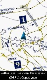
Screenshots
This KMZ map is set to Draw Order 32 so it will show 'beneath' your primary map on your Garmin KMZ-compatible GPS.
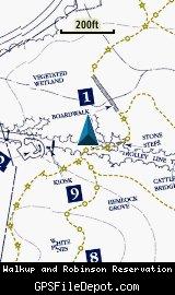
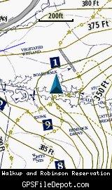
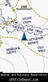
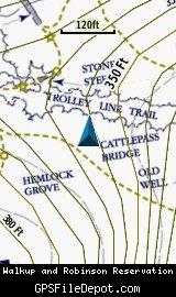
Note that due to the small fonts and intricate detail of this map, it is actually 4 tiles in order to maintain legible resolution. Keep that in mind when placing this on your Garmin GPSr - even though this is one KMZ, the number of tiles is limited to 100 across all the KMZ files loaded on your GPS.
The image on the left in each row below is from a Garmin GPSMAP 78sc with no other maps displayed. The image on the right in each row below is from the same device with the Garmin 24K NE series TOPO maps displayed.

Download
I have posted this KMZ as freeware, so instead of paying me for it, send me a note if you found this file helpful!
[email protected]
 Download Garmin Custom Map [883kB] (1075 Downloads)
Once you have downloaded and unzipped the KMZ file, you can:
1) Display it on your Garmin GPS receiver by placing the file in the \Garmin\CustomMaps folder on your supported Garmin GPS receiver. For a list of supported devices, click here.
2) Display it in Google Earth by opening the file (FILE, OPEN).
Notification of Updates
If you would like to be notified when I update this or any of my KMZ maps, subscribe to my notification e-mail service by sending an e-mail to [email protected] with the subject line "subscribe gps_maps"
This is a notification list only, and the only posts you will receive are when my KMZ maps are updated. Your e-mail address will not be used for any other purpose (or provided to anyone else except me).
Support The Effort
If you find the map and this website useful please consider making a donation to offset hosting costs.
* You don't need paypal to donate but that is who will process the donation.
Version History
Version 1.00 (2012 June 11)
Initial release using undated Sudbury Valley Trustees map downloaded on June 11, 2012.