Land Ownership Nevada Map
Created By: ced
Last Updated: September 24th, 2013 6:09am
Map Coverage:
North: 42°
West: 119°
East: 113.5°
South: 35.5°
Country: United States
State: Nevada
Price: 0
![]()
![]()
![]()
Most Popular Maps
- My Trails-High Quality Trail and POI Maps
- Arizona Topo
- World Topo - Eastern
- Florida Topo
- World shaded relief kmz
Other Maps By ced (See All)
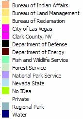
A Garmin Custom Map of the Land Status/Ownership in Nevada.
I found the data on the Nevada BLM site, used the official color model standards of the BLM and assigned colours that seemed sensible to the ones not specified there:
SMA_NV.zip contains two separate kmz files:
- SMA_NV_1tile.kmz contains a single tile, very low quality, but might be useful for a quick overview
- SMA_NV_28tiles(4x7).kmz moderate quality, but a bit slower
Both files can be used separately. If used in conjunction the "better" one doesn't show until zoomed in.
Please remember that this is not a vector map, so there may be (additional) errors due to compression artifacts. Always verify the correct status at the appropiate Field Office or Agency.
Tested in an Oregon 450 and Google Earth.
Source: http://www.blm.gov/nv/st/en/prog/more_programs/geographic_sciences/gis/geospatial_data.html
 Download Garmin Custom Map [1MB] (3066 Downloads)