Massachusetts: Hopkinton State Park (large scale) Map
Created By: dbperry
Last Updated: February 21st, 2013 5:02pm
Map Coverage:
North: 42.2673°
West: -71.5295°
East: -71.4979°
South: 42.2544°
Country: United States
State: Massachusetts
Price: Free
![]()
![]()
![]()
![]()
![]()
![]()
![]()
Most Popular Maps
- My Trails-High Quality Trail and POI Maps
- Arizona Topo
- World Topo - Eastern
- WV-VA-KY Dec-29 2025 Public Map
- Florida Topo
Other Maps By dbperry (See All)
Hopkinton State Park (detail / large scale), Hopkinton, MA 01748
CLICK HERE to preview the KMZ map in Google Maps
Hopkinton is best known as the starting point for the Boston Marathon, but Hopkinton State Park is one of the most popular State Parks in Eastern Massachusetts. The DCR map of Hopkinton State Park has two sides - a small scale map encompassing some of the less frequently hiked trails in the southwestern portion of the property, and a large scale map with detail of the trails and recreation areas in the main part of the Park. I have created KMZ maps of both, and by using the draw order of the KMZ files, both can be displayed on your GPSr at the same time and provide the benefits of both at the same time. [Well, it isn't quite that great. After loading both at the same time on my GPSr, I find that I must be zoomed in to the zoom level where the scale bar is 120 foot wide for this map to appear visible - at wider zooms (smaller scales) only the small scale KMZ appears. Oh well, it still functions, but not quite as good as I had hoped.]
This map is the detail / large scale map. My KMZ of the small scale map is available here.
For more information:
http://www.mass.gov/dcr/parks/northeast/hpsp.htm
And don't forget to rent a boat when you visit!
http://boatinginboston.com/hopkinton-state-park/hopkinton
Source Data
This KMZ is created from the DCR map at:
http://www.mass.gov/dcr/parks/trails/print/Hopkinton.pdf
See version history below for more information.
Screenshots
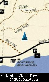
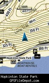
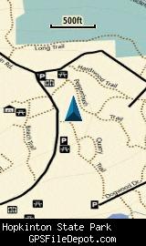
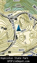
This KMZ map is set to Draw Order 28 so it will show 'beneath' your primary map on your Garmin KMZ-compatible GPS. It will show over my small scale map of Hopkinton State Park (as described above) but under my KMZ map of the Ashland Town Forest.
All of the images below are from a Garmin GPSMAP 78sc. The image on the left in each row is with no other maps displayed. The image on the right is with the Garmin 24K NE series TOPO map displayed.
Download
I have posted this KMZ as freeware, so instead of paying me for it, send me a note if you found this file helpful!
[email protected]
 Download Garmin Custom Map [164kB] (1281 Downloads)
Once you have downloaded and unzipped the KMZ file, you can:
1) Display it on your Garmin GPS receiver by placing the file in the \Garmin\CustomMaps folder on your supported Garmin GPS receiver. For a list of supported devices, click here.
2) Display it in Google Earth by opening the file (FILE, OPEN).
Notification of Updates
If you would like to be notified when I update this or any of my KMZ maps, subscribe to my notification e-mail service by sending an e-mail to [email protected] with the subject line "subscribe gps_maps"
This is a notification list only, and the only posts you will receive are when my KMZ maps are updated. Your e-mail address will not be used for any other purpose (or provided to anyone else except me).
Support The Effort
If you find the map and this website useful please consider making a donation to offset hosting costs.
* You don't need paypal to donate but that is who will process the donation.
Version History
Version 1.00 (2/20/2013)
Initial release using DCR map dated 2008
Map Summary
Site details:
Name: Hopkinton State Park (detail / large scale)
Owner / Steward: MA Department of Conservation and Recreation (DCR)
State: Massachusetts
County: Middlesex
Primary city / town: Hopkinton
Primary city / town zip code: 01748
Other cities / towns in map area: Ashland, Southboro
Area of conservation / recreation land: 506 acres or 0.79 square miles
NOTE: This is my calculation of the extents of the area(s) with publicly accessible trails on the KMZ map. This should be the area available for hiking or other recreation, but it will also include any portion of water bodies, marshes, swamps, etc. within the boundaries of the properties on the KMZ. It would also include inaccessible conservation land within the boundaries, such as a buffer zone of "Do not enter" land around a reservoir.
KMZ details:
File name: Hopkinton_SP_Detail_ver_1.00.kmz
Current version: 1.00
Date published: 2/20/2013
Number of tiles: 1
KMZ file size: 171 KB
Draw order: 28
Does this KMZ overlap with any others? Yes
If so, which ones? Hopkinton State Park (small scale) and Ashland Town Forest
Coverage of KMZ: 921 acres or 1.44 square miles
NOTE: this area includes the ENTIRE KMZ including white space / margins / legend, etc.
Lat / Long of center of KMZ polygon (not necessarily the center of the map):
N 42° 15.649'
W 71° 30.822'